don't be a sierra hater. embrace the future.lowflier03 said:Lol, sorry if you think the Romeo and the Sierra are going to have all nice new gear. They are still stuffed with 70's and 80's technology. Think pneumatic sonobouy launcher... What a space wasting piece of junk... The company that makes them isnt even around anymore, they had to spend a significant amount of time reverse-engineering one to make new ones for the Romeo... Its sad really.

-
Please take a moment and update your account profile. If you have an updated account profile with basic information on why you are on Air Warriors it will help other people respond to your posts. How do you update your profile you ask?
Go here:
Edit Account Details and Profile
You are using an out of date browser. It may not display this or other websites correctly.
You should upgrade or use an alternative browser.
You should upgrade or use an alternative browser.
Acls?
- Thread starter Fly Navy
- Start date
Harrier Dude
Living the dream
squeeze said:I know you're not implying that the AWLS is a waste of money and could be replaced with an ILS. Blasphemy.")
I think that with the symbology for the AWLS already established in our software, it would stand to reason that by changing boxes and recievers, you could plug an ILS box in and it would work.
Oustide of the 203 sim, have you ever tried to use it? I tried once at CAX (didn't work at all) and once at the boat (didn't work, but won't discount my own possible switch-pigging). What a piece of FOD.
I have talked to some dudes that were able to use it on their boat, and they liked it except that you lose DME. That would help for hoverstop cues and closure rates.
Where are you at?
ChuckMK23 said:TACAN is a nice tool in the very narrow , limited world of finding a moving ship - BUT THAT's IT. It's bad airmanship not to use your GPS for primary navigation reagrdless whether the morons at NAVAIR have it "IFR Certified" or not. My 2 cents- and if I'm the PIC/HAC that's the way we would do it in my A/C
I'm not going to use my GPS in my MH-60S for IFR flight even though it is very easy to input the lat/long of a navaid and drop a reference point down to nav off of. Bearings off of the GPS won't necessarily match the radials off of the actual navaid (since the GPS doesn't know the actual error that is in the navaid that the charts take into account). That's why the 3710 reads the way it does. On the other hand, I love my GPS as another tool to confirm my VFR fixes; or even OTH at sea with no ship TACANS to pick up enroute!
lowflier03 said:Lol, sorry if you think the Romeo and the Sierra are going to have all nice new gear. They are still stuffed with 70's and 80's technology. Think pneumatic sonobouy launcher... What a space wasting piece of junk... The company that makes them isnt even around anymore, they had to spend a significant amount of time reverse-engineering one to make new ones for the Romeo... Its sad really.
They had glass cockpits, miniaturized computers, and ring laser gyros at the heart of their embedded GPS/inertial navigation systems back in the 70's? I don't know about the ROMEO, but the SIERRA is alright. Of course, they could have done better to just go with a brand new tandem-rotor design using updated technology, but at least we aren't crashing Navy phrogs anymore.
justme said:I'm not going to use my GPS in my MH-60S for IFR flight even though it is very easy to input the lat/long of a navaid and drop a reference point down to nav off of. Bearings off of the GPS won't necessarily match the radials off of the actual navaid (since the GPS doesn't know the actual error that is in the navaid that the charts take into account). That's why the 3710 reads the way it does. On the other hand, I love my GPS as another tool to confirm my VFR fixes; or even OTH at sea with no ship TACANS to pick up enroute!
You know in a lot of GPS's you can enter the Mag Var for each waypoint... that would take care of that little problem right there.
The Prowler EGI factors that in automatically - non issue.Fly Navy said:You know in a lot of GPS's you can enter the Mag Var for each waypoint... that would take care of that little problem right there.
Basking in the Rivierra sun,

Brett
ah, the Boeing 360.justme said:They had glass cockpits, miniaturized computers, and ring laser gyros at the heart of their embedded GPS/inertial navigation systems back in the 70's? I don't know about the ROMEO, but the SIERRA is alright. Of course, they could have done better to just go with a brand new tandem-rotor design using updated technology, but at least we aren't crashing Navy phrogs anymore.
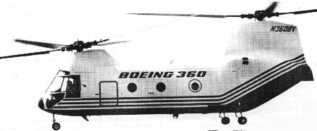
Mr. Gorman (60 sim guy) and my former phrog-driving O-4 sim buddy were talking today about the 360 and how Bell convinced Boeing to shelve it in favor of a "joint tiltrotor development project." Also, they talked about a feature of early phrogs that I forget the name of, but it allowed you to tilt the rear head aftward without tilting the forward head... anyone know what I'm talking about and why it was on there?
Would you believe we have the same navigation problems in the MH-47G? We have dual EGI(GPS)/ INS, Doppler, four-axis auto pilot, and the ability to couple TCN, GPS, ILS (even back crs), VOR, etc. Still, technically we aren't allowed to conduct GPS approaches in the terminal area because our data base is "corruptable." We can couple our ILS and it automatically levels off at 50' AGL if you really have to get down.
Our SOP is to navigate the airway system and approach using traditional nav aids/needles(coupled of course with the flight director), but have the GPS flight plan overlayed on the moving map to see if there are course deviations. At some points there's as much a 1.5 nm deviations between GPS nav and radio nav. We will usually go with the erred radio nav since that's what ATC is using as well.
Our SOP is to navigate the airway system and approach using traditional nav aids/needles(coupled of course with the flight director), but have the GPS flight plan overlayed on the moving map to see if there are course deviations. At some points there's as much a 1.5 nm deviations between GPS nav and radio nav. We will usually go with the erred radio nav since that's what ATC is using as well.
Pags said:don't be a sierra hater. embrace the future.
I love the Sierra! It will make a great replacement for the TH-57.

S.O.B. said:I love the Sierra! It will make a great replacement for the TH-57.
I take that back. The airframe would never be able to handle that kind of abuse.
Yup, the OAMCM project is proceeding. No one really wants the mission, though.Helo Guy said:Great replacement for the 46 or H1 but that's it. Are they still looking at using it for AMCM?