• Please take a moment and update your account profile. If you have an updated account profile with basic information on why you are on Air Warriors it will help other people respond to your posts. How do you update your profile you ask?

    Go here:

    Edit Account Details and Profile

U-2 Pictures, as requested

HuggyU2

Well-Known Member
None
Here's a few I found. I've got better ones around somewhere, and will post them when I get them.
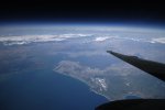
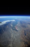
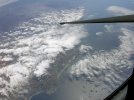
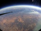
Left to right: Bay Bridge (twice), La Jolla (near San Diego), Lake Tahoe, central valley near NAS Lemoore
 

Attachments

  • Bay Bridge2.jpg
    Bay Bridge2.jpg
    112.5 KB · Views: 1,228
  • Bay Bridge.jpg
    Bay Bridge.jpg
    390.5 KB · Views: 1,040
  • La Jolla.jpg
    La Jolla.jpg
    85.5 KB · Views: 961
  • Tahoe.jpg
    Tahoe.jpg
    82.8 KB · Views: 1,100
  • Valley.jpg
    Valley.jpg
    117.9 KB · Views: 972

East

东部
Contributor
Thanx for sharing

That's what I call an office with a view......BTW Missing Col. Sarnac in those pics :D
 

Schnugg

It's gettin' a bit dramatic 'round here...
None
Super Moderator
Contributor
That's amazing. You can actually see the curvature of the Earth.

A wide angle lens can also do that (last two images especially), too.

I'm sure these were taken above my max attained altitude of 54,000'. But the sky does get dark up there and you can begin to see a curve to the horizon.
 

HuggyU2

Well-Known Member
None
Schnugg's right: the camera really makes it look more "curvy" than it really is. But the dark blue/black sky overhead is pretty accurate. Sunset/sunrise can be spectacular.
 

HuggyU2

Well-Known Member
None
Incredible! What altitude were those taken from (or is that classified)?
The climb profile settles down once you get above FL600. That's when most folks pull out the cameras. So some were probably above 600, and some above FL 700.
 

skim

Teaching MIDN how to drift a BB
None
Contributor
the second one is now my desktop background. thanks.
 
Top