
-
Please take a moment and update your account profile. If you have an updated account profile with basic information on why you are on Air Warriors it will help other people respond to your posts. How do you update your profile you ask?
Go here:
Edit Account Details and Profile
You are using an out of date browser. It may not display this or other websites correctly.
You should upgrade or use an alternative browser.
You should upgrade or use an alternative browser.
Carrier dimensions?
- Thread starter kmac
- Start date
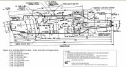
Here you go. LSO Ref Manual, Appendix A, Pg A-6.
Anything worth doing is worth overdoing, so here's one more powerpoint - a comparison of Hooverpilot's diagram with the measurements Google Earth gives. As you can see, it's not exact, but good enough for govt work.
I did this because a) I'm still bored, and b) it was a good little exercise in Google Earth accuracy. I'm a big fan of the tool, especially on the classified side - but it's amazing the pushback I get from the "traditional" geospatial folks, who view it with a "not invented here" perspective and as a threat to their jobs and livelihood. Examples like this show that GE does have both good geopositional accuracy as well as precision measurement, and can be used for a lot more than just finding directions to Grandma's house, or seeing what the house you grew up in as a kid looked like.
Mark my words - this tool is the wave of the future on the intel side. With this and Powerpoint, we'll have...well, let's see...we'll have more stuff to show in Powerpoint!
")
Combine that with night and the carrier is as big as a FFG!
Is that really true? I asked a similar question a few years back and hadn't heard it put in perspective like that. Oh, and for the standard jet dig: I always liked the FFGs because they're pretty big. Smiles of course.
MasterBates
Well-Known Member
gator, when I showed a guy here the "acceptable" Pitch/Roll limits for FFG/CG/DDG out of my PCL, he about shat himself..
(had another LT here ask the question, as he wanted to increase his knowledges before going to CAG staff)
(had another LT here ask the question, as he wanted to increase his knowledges before going to CAG staff)
Well, we all know that dark air produces less lift. Paddles taught me that in flight school!Pitching deck somehow invokes an accordian effect as well, making the deck shrink. Combine that with night and the carrier is as big as a FFG!

GroundPounder
Well-Known Member
Well, we all know that dark air produces less lift. Paddles taught me that in flight school!
Only in the manly world of Naval Aviation. On the civil side, dark air produces the same amount of lift but twice the amount of strange engine noises of lighted air.

