
-
Please take a moment and update your account profile. If you have an updated account profile with basic information on why you are on Air Warriors it will help other people respond to your posts. How do you update your profile you ask?
Go here:
Edit Account Details and Profile
You are using an out of date browser. It may not display this or other websites correctly.
You should upgrade or use an alternative browser.
You should upgrade or use an alternative browser.
Can some one label the picture for me?
- Thread starter Sabre170
- Start date
- Status
- Not open for further replies.
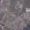
Not really sure about the OCS-related areas but it is definitely NASP. When was this photo taken? Interesting to see there is still a lot of hurricane damage (roofs still partially missing, some newly replaced, and A-school barracks still trashed). Also interesting to see the E-2s, F-14s, and Blue Angels in the lower right quadrant by the baseball fields. I didn't know those were over there so far from the flight line.
Thisguy-
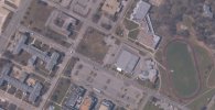
That's not Batt I/II. Batt II is the building to the lower left of where you cropped, with Batt I being to the lower left of that one. You can see Regiment straight across the street from Schools Command (where the Hornet display is in the lower left)
That's not Batt I/II. Batt II is the building to the lower left of where you cropped, with Batt I being to the lower left of that one. You can see Regiment straight across the street from Schools Command (where the Hornet display is in the lower left)
Sabre170 said:This picture was taken right after the summer storms. As for Pags, I'm not a terrorist, just a guy who will be reporting in for OCS in a couple of weeks (Jan 23) and wanted to have an idea of the area I will be heading down to.
I figured as much, it was mostly a joke
Sandwichwarrior
Hauling ass so others don't have to.
The H shaped buildings in the top right are the OCS/Aircrew area but most of the picture is NATTC (Naval Aviation Tech. Training Center)
Those aircraft Makana pointed out in the bottom right don't fly they're just there for the ground crew trainees to practice on, Note the CV outline painted on the tarmac.
Those aircraft Makana pointed out in the bottom right don't fly they're just there for the ground crew trainees to practice on, Note the CV outline painted on the tarmac.
Thisguy
Pain-in-the-dick
kmac said:Thisguy-
That's not Batt I/II. Batt II is the building to the lower left of where you cropped, with Batt I being to the lower left of that one. You can see Regiment straight across the street from Schools Command (where the Hornet display is in the lower left)
My bad...thanks for the correction
I know that when I left in '98 they were rehabing some of the buildings and people who I've spoken with have indicated that they stayed in different places than I did. Of course, NASC is still in the same spot. Picture is kind of weird - all the parking lots are empty. Jackpot!
Brett
Brett
Patmack18 said:Hahaha I can see the SUYA from space!
Funny-
I can almost taste the SUYA from space! :icon_rage
engineman02
ENS
I didnt look that closely at the picture the first time to notice it was post Ivan. Now I can really tell. I really noticed it when I saw all the sand on the road running along the waterfront by the batt buildings (radford i believe). I was lucky enough to be there when all this mess went down, but luckily it happened about 2 weeks before graduation. The only bad part was the suya got through it all. But it didnt really matter for us since we never got to see it again :icon_mi_1 .
- Status
- Not open for further replies.