• Please take a moment and update your account profile. If you have an updated account profile with basic information on why you are on Air Warriors it will help other people respond to your posts. How do you update your profile you ask?

    Go here:

    Edit Account Details and Profile

Air Force v.s. Navy Culture Differences

Gatordev

Well-Known Member
pilot
Site Admin
Contributor
JSF SAP mission planning computers means that JSF uses occasionally delivered DAFIF discs from NGA, uploaded into SAP JMPS and forgotten about. No RNAV capability, can load a few hundred points to the jet by referencing them in JMPS, or by using the world's greatest EFB (MAGTAB) to search and transcribe the lat/long.

USMC JSF doesn't allow any other EFB (restrictive SAP SOP), so we use contracted Samsung MAGTABs running AeroApp with data downloaded periodically from the NGA Aeronautical website and manually transferred to the Linux MAGTAB hub computer. Especially frustrating watching Navy JSF pulling out Foreflight in the same plane.

Interesting. I'm surprised the number of points is so low in a such a "new" AOP. Sounds like you don't ever mess with the points, but do they include the waypoint data, like runways or freqs?

Jeppesen has been contracted DoD wide to provide service validated DAFIF data through a packaging service that is fully integrated with JMPS according to the folks here - P-8 and E-2D were native launch platforms for Navy - presenter talked through other platforms that are being released this year and next. I did not hear V-22. But Boeing and Jepp basically got the big thumbs up over NGA it sounds like. Default will be Jepp data in All service aircraft with FMS.

I still don't know what that means. When they are saying "DAFIF data," is it just the waypoint data or is it additional graphical data that can be displayed (kind of like GMX-200 charts)? NGA DAFIF data is just waypoint data, the same you'd find in any GPS database, and it actually has a lot of information in it (basically the equivelent of the "Airport" tab in Foreflight).

This sounds a lot like when you purchase databases from Garmin and you have the two options: 1) Garmin for a lot of money or 2) Jeppsen for a lot of money plus $100. It's Jeppsen, so it's better! But in the end it's the same data. Where the Jepp data excels is the graphical representation of the FLIP stuff, assuming you have a system that can display it. I'm guessing the P-8 can display it, but a lot of the other fleet aircraft won't be able to (see the F-35 post above).
 

ChuckMK23

FERS and TSP contributor!
pilot
I still don't know what that means.
Getting our aircraft fully PBN compliant - and for FMS 's to contain the same data as 121 Air Carriers with Jepp doing integration of NGA only FLIP data - like AR tracks, IR/VR's, and accredited host nation data - aka "global reach". Your box contains all the departures enroute and terminal nav an procedures with the data set fully validated and PBN compliant - so when your airplane gets full RNP spectrum of RNP capability, you have the database. More geared to transport category jet folks but I imagine you need it in helos and certainly plopters.
 

ChuckMK23

FERS and TSP contributor!
pilot
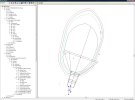
One of the interesting takeaways from the instruction on TERPS and procedure design from "Terpsters" is the airspace around holding patterns. I always remember "thow shall stay on the protected side of the holding pattern or you will die" - well after hearing the folks who actually design procedures, the truth is this is a purely academic statement. In truth, there is almost as much protected airspace on the non-holding side and you are in actuality perfectly safe to maneuver on the non holding side as needed - even beyond just a parallel entry.

Here is a screen shot of the DPS software from our exercise in designing a TACAN approach:

1670785883247.jpg

And... 4 different obstacle evaluation areas depending on altitude - 2-4K, 4-6K, 6-8 K, 8-10K each widening with alt. Quite a conservative amount of airspace is evaluated and validated as non-penetrating, obstacle free.
 
Last edited:

insanebikerboy

Internet killed the television star
pilot
None
Contributor
Getting our aircraft fully PBN compliant - and for FMS 's to contain the same data as 121 Air Carriers with Jepp doing integration of NGA only FLIP data - like AR tracks, IR/VR's, and accredited host nation data - aka "global reach". Your box contains all the departures enroute and terminal nav an procedures with the data set fully validated and PBN compliant - so when your airplane gets full RNP spectrum of RNP capability, you have the database. More geared to transport category jet folks but I imagine you need it in helos and certainly plopters.
The goal of PBN is increased safety in IMC conditions. Realistically RNP 0.3 is what would be needed to keep rotorcraft safe in low level IMC conditions. Higher RNP (1, 2, etc) would naturally drive the route altitude higher but would also drive the rotorcraft into higher potential for icing conditions.

I think the hurdles for the Navy, and rotor/tilt rotor aircraft in general, to achieve PBN are pretty damn large. First are the onboard hardware requirements for self-monitoring to ensure nav accuracy, which wouldn’t be that tough, it would just take some money. Even more than that is the need to validate PBN segments. It’s easy to TERP an approach around a field but to validate the multitude of routings possible at low level takes a lot of time and money, and considering the lesser number of end users when compared to fixed wing, I can’t imagine it’s a high priority for the FAA.

The last time I looked at PBN/RNP nav was a few years ago when I was thinking of getting out of the Navy, so my info might be dated. I recall there were some HEMS operators and hospital districts in the NE that had created a ‘private’ PBN route network. Other than those few, I’m not aware of much RNP 0.3 low level.

I do think that the Navy will get to RNAV capabilities for helos and tilt-rotor, if they haven’t already, I just can’t see them funding PBN capabilities in the aircraft for a very minimal return in the FAA and ICAO nav structure.
 

gparks1989

Well-Known Member
pilot
Contributor
I disagree, and I fly with ForeFlight every flight. It is not a MEL item.

If you can’t navigate, using paper pubs, without ForeFlight then you have absolutely zero business flying with it.

ForeFlight is an aid, not a crutch. There’s a significant difference between the two.
Don't know about FF being an MEL item, but what does paper buy you that Foreflight doesn't? Tons of paper pubs weighs down your helmet bag and makes (for me) an already tight cockpit even more uncomfortable.
 

HuggyU2

Well-Known Member
None
I only began flying with ForeFlight in lieu of paper pubs in the single-seat military environment 2 years ago. After 30 years of using paper, it took some getting used to.

We don't carry paper anymore and are exclusively iPad... so it's up to me to adapt. But there is nothing wrong or unsafe with paper.

And frankly there are a few things about paper that are better.
 

insanebikerboy

Internet killed the television star
pilot
None
Contributor
Don't know about FF being an MEL item, but what does paper buy you that Foreflight doesn't? Tons of paper pubs weighs down your helmet bag and makes (for me) an already tight cockpit even more uncomfortable.
It’s not paper pubs per se, it’s relying on the magenta line vs actually reading instruments and correlating that with what’s on the pub.

The iPad and FF is awesome because I have 100% of the DoD FLIP available to me while flying.

I do miss being able to write on my paper approach plate though, that was actually pretty handy.
 

Hopeful Hoya

Well-Known Member
pilot
Contributor
Interesting. I'm surprised the number of points is so low in a such a "new" AOP. Sounds like you don't ever mess with the points, but do they include the waypoint data, like runways or freqs?

Nope, think basic JMPS waypoints with a lat/long/elevation. Flying locally it isn’t much of an issue, but if you want to go on the road you essentially need to mission plan the route and expected waypoints to have them in the jet, since there is no RNAV database like the Super Hornet has. And if you get revised routing from ATC, and you can’t use an iPad, you’re back of the realm of asking for an initial steer and trying to find the point in question on the High or Low chart…
 

Gatordev

Well-Known Member
pilot
Site Admin
Contributor
Getting our aircraft fully PBN compliant - and for FMS 's to contain the same data as 121 Air Carriers with Jepp doing integration of NGA only FLIP data - like AR tracks, IR/VR's, and accredited host nation data - aka "global reach".

More geared to transport category jet folks but I imagine you need it in helos and certainly plopters.

I get it now. Two points...1) I think I was reading the "FMS" part but it wasn't fully registering. 2) It seems like this assumes that there are only two options...NGA or Jepp. For OCONUS, Jepp is certainly the better option, but I'd argue that domestically, only using NGA products is a self-induced handicap. The FAA has DAFIF for everything, so that should be a third option rather than having your hands tied and going through the extra steps of asking NGA to include an FAA set of data into NGA. We had to do that at Whiting at one point because NGA (or whomever it actually is) decided to take KMVC out of the FLIP, despite it being a major instrument training location. Yes, we could just grab the available FAA pub, but those were limited in the pubs room (again, back with paper), so not everyone had them. I can't remember if airnav.com was a thing yet, and I can't remember if some of us would just print the plates out and have them in our blue brains.

Fortunately it only took a pub cycle to get the approaches back in the FLIP.

So now a question about Jepp that maybe they covered... As part of this process, is this making all of the Jepp approaches legal DoD-approved approaches? That seemed to be a major negative of Jepp for OCONUS options. I could see Boeing wanting to make this happen.

Getting our aircraft fully PBN compliant

I think IBB was alluding to this, but is getting USN aircraft fully PBN compliant with RNP an actual requirement? I get we all want to have RNAV capability, but I've really only heard the goal was ADS-B compliance.

Nope, think basic JMPS waypoints with a lat/long/elevation. Flying locally it isn’t much of an issue, but if you want to go on the road you essentially need to mission plan the route and expected waypoints to have them in the jet, since there is no RNAV database like the Super Hornet has.

Interesting. That was how the -60s were in earlier software and hardware versions. As the mission computers were upgraded (along with the AOP), more room was available to have the full spectrum of wayponts and nav data (but no RNAV procedures). I figured the JSF would be a generation ahead in mission computer capability and would have the DAFIF room/capability.
 

sevenhelmet

Low calorie attack from the Heartland
pilot
As I recall, we could do that at AA with FD Pro.

You can write and draw on approach plates in Foreflight too, but it's not quite the same as pen and paper. It is useful for things like taxi clearances at big airports (I fly little planes, so we don't go to the really big airports often.)

I just fly with a kneeboard, and use that to write things down.
 

kmac

Coffee Drinker
pilot
Super Moderator
Contributor
I get it now. Two points...1) I think I was reading the "FMS" part but it wasn't fully registering. 2) It seems like this assumes that there are only two options...NGA or Jepp. For OCONUS, Jepp is certainly the better option, but I'd argue that domestically, only using NGA products is a self-induced handicap. The FAA has DAFIF for everything, so that should be a third option rather than having your hands tied and going through the extra steps of asking NGA to include an FAA set of data into NGA. We had to do that at Whiting at one point because NGA (or whomever it actually is) decided to take KMVC out of the FLIP, despite it being a major instrument training location. Yes, we could just grab the available FAA pub, but those were limited in the pubs room (again, back with paper), so not everyone had them. I can't remember if airnav.com was a thing yet, and I can't remember if some of us would just print the plates out and have them in our blue brains.

Fortunately it only took a pub cycle to get the approaches back in the FLIP.
I’m curious to hear your opinion on why you think Jepp is a better option, overseas but especially domestically.
“The FAA has DAFIF for everything.“ -You have it the other way around. DAFIF is a DoD product. It includes all of the FAA data.
“We had to do that at Whiting at one point because NGA (or whomever it actually is) decided to take KMVC out of the FLIP… -Deletions of airfields out of FLIP is a service Office of Primary Responsibility call. In fact, the only FAA fields within DoD field are the ones requested by the military services. Otherwise DoD FLIP would be as large as the FAA FLIP. (Meanwhile, DAFIF does include all of the US)
“Fortunately it only took a pub cycle to get the approaches back in the FLIP.” -For USN/USMC, it’s imperative that units contact NAVFIG if they want a civilian field included in FLIP.

One thing that isn’t probably clear to this group is how any aeronautical data gets into DoD FLIP and DAFIF. If it’s aeronautical procedural data (e.g., courses, altitude/speed restrictions, minima), the data comes from a military service TERPS shop. This is why minima may be different on a DoD plate compared to a host nation (and Jepp) plate. The DoD has done obstacle evaluation and has risen minima to match the same safety level as provided by US TERPS. For foundation data (e.g., runway dimensions, airport elevation) there are several validation tools/processes used by NGA to collect the most accurate information. This is something that Jeppesen does not do. They follow host nation, even if host nation uses a non-standard definition for a data element (e.g., airport elevation).

I’m happy to answer any questions regarding DoD FLIP/DAFIF. Otherwise I’m looking forward to the briefing that ChuckMK23 has.
 

Gatordev

Well-Known Member
pilot
Site Admin
Contributor
I’m curious to hear your opinion on why you think Jepp is a better option, overseas but especially domestically.
I personally find Jepp plates to be overly busy, but a lot of people like them better than the domestic design. I think what goes along with that is a clearer depiction of an approach on Jepp plates than what is sometimes displayed on a rinky-dink approach into Kerblackistan.

My comment was based on what others have told me about flying internationally and Jepp. Domestically, I agree, I find FAA plates better, but I also don't fly STARS very often.
“The FAA has DAFIF for everything.“ -You have it the other way around. DAFIF is a DoD product. It includes all of the FAA data.

My understanding is that "DAFIF" is the file, albeit a military file. What's in the file will depend on the source. Poor wording on my part to refer to the FAA data as "FAA DAFIF." What I was getting at is that the FAA has a set of files (whatever we want to call them) that has all of the data. As a civilian, we interact with those files every 28 days, just like the NGA DAFIF gets updated (or is supposed to) on the military side.

I'm clarifying my statement not because I'm arguing your point. I agree, it's a valid correction.

“We had to do that at Whiting at one point because NGA (or whomever it actually is) decided to take KMVC out of the FLIP… -Deletions of airfields out of FLIP is a service Office of Primary Responsibility call. In fact, the only FAA fields within DoD field are the ones requested by the military services. Otherwise DoD FLIP would be as large as the FAA FLIP. (Meanwhile, DAFIF does include all of the US)
“Fortunately it only took a pub cycle to get the approaches back in the FLIP.” -For USN/USMC, it’s imperative that units contact NAVFIG if they want a civilian field included in FLIP.

Ah, NAVFIG. Thank you, that was another name that I had forgotten. And yes, that's what happened. Someone above the Wing decided to remove the plates, and the Wing reached back out and got them put back in.

One thing that isn’t probably clear to this group is how any aeronautical data gets into DoD FLIP and DAFIF. If it’s aeronautical procedural data (e.g., courses, altitude/speed restrictions, minima), the data comes from a military service TERPS shop. This is why minima may be different on a DoD plate compared to a host nation (and Jepp) plate.

Which goes back to my earlier question. If Boeing has this program where they're including all of this Jepp information to make DoD aviation great again...is it actually approved for use by DoD, since it hasn't gone through the DoD FLIP chop process in a post-Sec. Brown world.

Intent by industry is great, but as you point out, if it's not legal to use, it's not all that helpful.

@kmac I wasn't sure if you were around following this thread, but I was hoping you were going to chime in with your perspective.
 

kmac

Coffee Drinker
pilot
Super Moderator
Contributor
I personally find Jepp plates to be overly busy, but a lot of people like them better than the domestic design. I think what goes along with that is a clearer depiction of an approach on Jepp plates than what is sometimes displayed on a rinky-dink approach into Kerblackistan.
Reservists who use Jepp plates in their civilian flying tend to like using them for military flying. I think each have advantages and disadvantages. The whole point of DoD FLIP, going back to the 1960s, is to have the same format across US government charts. The FAA produces by far the majority of charts found in the US DoD FLIP volumes. The FAA holds public meetings twice a year where recommendations can be submitted (Aeronautical Chart Meeting). Those recommendations are sent to the Interagency Air Committee (i.e., NGA and FAA) for adoption into the product specifications. If anyone wants a change, that’s the best way to make it happen.

My understanding is that "DAFIF" is the file, albeit a military file. What's in the file will depend on the source. Poor wording on my part to refer to the FAA data as "FAA DAFIF." What I was getting at is that the FAA has a set of files (whatever we want to call them) that has all of the data. As a civilian, we interact with those files every 28 days, just like the NGA DAFIF gets updated (or is supposed to) on the military side.
You are right. The FAA has the Coded Instrument Flight Procedures file. Either way, it’s data that conforms (to varying degrees) with the ARINC 424 standard. That is the Type I data. Then it gets processed by a Type II data provider for inclusion into an aircraft’s FMS or mission planning software.
Ah, NAVFIG. Thank you, that was another name that I had forgotten. And yes, that's what happened. Someone above the Wing decided to remove the plates, and the Wing reached back out and got them put back in.
NAVFIG is within the Navy’s ATC realm, so unless a flying unit contacts them directly they probably aren’t aware of fleet issues. I’m actually surprised that there isn’t a direct link between CNAF (flying policy) and NAVFIG (flight procedure design). They don’t seem to meet until N98. The USAF at least has the Advanced Instrument School for which AFFSA (head of USAF TERPS) can turn to with fleet questions.
Which goes back to my earlier question. If Boeing has this program where they're including all of this Jepp information to make DoD aviation great again...is it actually approved for use by DoD, since it hasn't gone through the DoD FLIP chop process in a post-Sec. Brown world.

Intent by industry is great, but as you point out, if it's not legal to use, it's not all that helpful.

@kmac I wasn't sure if you were around following this thread, but I was hoping you were going to chime in with your perspective.
You hit the nail on the head. There is a bit of a push from the Services to use Jeppesen for worldwide coverage (a ‘requirement’). Yet, it was the Ron Brown mishap that resulted in a DoD policy to evaluate/approve foreign procedures before any troop transport or passenger aircraft could fly it. Now it becomes a matter of cost/resources. Do the military services have the budget to 1) purchase JMCS and 2) validate procedures*? I don’t know the answer to that. The reason that the Electronic-Instrument Procedures Library (E-IPL) exists is to have worldwide, ready procedures that can be quickly evaluated if needed at no additional cost to the services. The Army and several allied nations have adopted using E-IPL. The USAF and USN are holdouts. I’m sure there will be more to follow.

*TERPS validation, not just a data validation
 
Top